
COL DU SAMBUIS
- angelogeorge988
- Sep 7, 2024
- 8 min read
Updated: Apr 25, 2025
This is a loop route through the Stone Heart of the Belledonne Massif in the French Alps. The trail is characterized by its abundance of stones and rocks, with the exception of a relatively short section at the beginning and end. If you have a passion for stone and rock formations and are an experienced mountaineer, this route is perfect for you.

The Loop
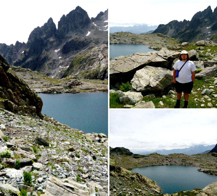
This circuit route begins at Col du Glandon and leads to Lac de la Croix (Lake of the Cross) at 2,415 meters. From there, it ascends to Col du Sambuis, the highest point at 2,528 meters. The route then descends to Lac du Sambuis at 2,431 meters before returning to Col du Glandon. The section from Col du Glandon to Lac de la Croix is well-marked and fairly busy, with over 100 hikers per day during the summer months. However, the stretch between Lac de la Croix and Lac du Sambuis lacks signage and is not frequented by anyone except experienced mountaineers. This part of the route is the wildest and most challenging but also the most rewarding. From Lac du Sambuis, the return to Col du Glandon is straightforward, following a marked trail that leads to the summit of Cime du Sambuis. This trail is well-signposted but less traveled, as it is more difficult than the one to Lac de la Croix.

The Preparation
My youngest son, Vlad, and I didn't tackle the route immediately upon arriving in the mountains. Instead, we began by 'warming up' with three shorter hikes, one of which headed in the direction of Lac de la Croix, though we didn't reach it. Following this, we took a mandatory rest day due to rain. Despite the weather, we took the opportunity to explore the medieval site of Conflans (Cité médiévale du Conflans) in Albertville. A dedicated article on this excursion will be published soon on the blog.

Therefore, it was not until the fifth day of our mountain holiday that we embarked on this route. Well-prepared, we completed it in less time than the estimate provided by its author—6 hours for us compared to his one day. However, I must admit that this accomplishment was partly aided by a breakfast blunder I made that morning.

A Breakfast Blunder?
The day before, we had bought a blueberry tart from the bakery ('boulangerie' in French) that we enjoyed immensely. For the following day, we intended to try other varieties. However, when I went shopping for breakfast, the baker offered me a blueberry tart made with a new recipe. Unable to resist the temptation, I decided to give it a try.

The new old... same
When I returned home, I proudly informed Vlad that I had bought a different blueberry tart, made with a new recipe. Vlad responded with a detailed explanation, reminiscent of a kindergarten lesson, that a blueberry tart is still a blueberry tart, regardless of whether it’s made with the same recipe as yesterday’s or a different one. Despite his philosophical stance, he eagerly devoured the tart in no time!

We Start the Hike
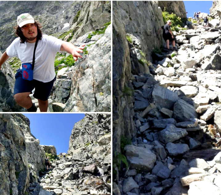
The initial part of the route follows a path that meanders along a hillside. It is relatively easy to walk, provided you don’t suffer from altitude sickness or vertigo. At times, the path narrows, and the valley to the right takes on the appearance of an abyss. We proceed slowly and steadily, noticing that the path gradually shifts from a grassy surface to rocky terrain. This change signifies that we are entering a more challenging phase of the hike: the trail is no longer straightforward and requires careful footing to avoid sprains or, worse, fractures.
As we adhere to the mountain's demands, we continue onward, simultaneously admiring the stunning landscapes unfolding before us. Enchanted by these rugged views, we hardly notice when we pass through a pasture and enter a rock-guarded valley, known as a 'combe' in French. Here, we encounter the imposing pillars of the landscape.

The Marking Posts
It's important to note that mountain boots are essential on trails like this one. They provide crucial stability and help minimize the risk of dislocation, sprain, or fracture if your foot slips or you step unevenly. First, we encounter a post marking the name of the valley we've just entered: Combe de la Croix (Valley of the Cross, photo below). A few hundred meters further, we come across a second post, directing us toward the summit of Cime du Sambuis, at 2,734 meters (top photo).

The perfect spot to pause
As we venture further into the valley, we notice the 'Aiguilles de l'Argentière' towering to our left and, to our right, the impressive horizontal rock formations that define the stunning Sambuis section of the massif. This is the perfect spot to pause with a specific purpose: to capture some memorable photographs.

The Photo Shoot
During my first visit here with Vlad in 2023, we took photos of ourselves against the stunning mountain backdrop and shared them with friends and family. The images were so well-received that we made it a point to repeat the photo session every time we passed by. Naturally, we continued this tradition on this special day. I took a photo of Vlad with the Aiguilles de l'Argentière in the background and one of myself with the Sambuis cliffs behind me.

The Fountain
We continue our trek toward Lac de la Croix, where the path alternates between flat stretches and gentle inclines. Eventually, we encounter a section where the trail becomes steeper, leading into a rocky corridor with a pronounced incline extending approximately 50 meters. Navigating this section requires increased attention and concentration.
The Best Water
Along the path, a spring flows, creating small waterfalls at various points, one of which I’ve nicknamed the 'Fountain'—a name that makes sense given its appearance. Each time we passed by, we would fill our bottles with the fresh mountain water, and Vlad never fails to remark that it is "the best water he’s ever tasted in his life."

Goofy Daddy Strikes Again
After completing the more challenging section, we take a brief break to rest, catch our breath, and regain our strength. We hydrate with plenty of water, savoring its coolness, especially after the warmth outside. We then face one last ascent before reaching Lac de la Croix. This final stretch is quite steep and traverses a rocky terrain, making the path less visible. I make another misstep, veering a few meters to the left of the intended route, which makes the climb more arduous than it would have been otherwise. Fortunately, this detour has a silver lining: it leads us to a vantage point above the lake, offering a stunning view of Lac de la Croix.
Repeatedly Blundering Dad
What happens next proves I truly deserve the title of 'repetitive blunderer.' It’s past noon, and we stop to eat. We find a perfect boulder to use as a table and open our picnic basket (actually a thermally resistant backpack). Vlad searches for his favorite ham—a local artisanal product of exceptional quality—but can't find it. He asks me what happened to it. I confidently assert that I’m sure I bought it, though I begin to doubt whether I actually packed it. Vlad responds dryly, suggesting that either I forgot to pack it, or it mysteriously became 'invisible.' Despite the mix-up, he doesn’t get upset and continues to amuse himself, accustomed to my blunders. The mishaps don’t end here, as the next day’s picnic features ham but, inexplicably, no bread! Otherwise, everything goes smoothly; after a brief break to digest lunch, we set off for Col du Sambuis.

Col du Sambuis
Here's something to keep in mind: since there are no official markers for the section leading to Col du Sambuis and then to Lac du Sambuis, we'll rely on a route created by a mountaineer and posted on a hiking app. Our success with this route will vary, as you'll see.
We navigate over stones and rocks, with occasional climbs. It’s not easy, but it’s incredibly rewarding: moving from one boulder to another, feeling the solid rock under our boots, and finding the best way to scale each obstacle is part of the unique charm of a mountain hike. We need to stay focused throughout, but the inherent danger at every step only deepens our appreciation for the mountain. It constantly reminds us that, despite our efforts, the mountain—His Majesty—is wild and untamable by man. Our careful navigation is also a way of showing respect for the mountain and its surrounding nature. As a bonus, we spot black goats near Col du Sambuis.

'Little' Climbing Session
From Col du Sambuis, we begin our descent, aiming to follow the route directions on the app as closely as possible. However, on the ground, we end up navigating more by foot, leading us to a steep section where we must use our hands to proceed. Hoping to avoid a repeat of this challenging experience, we look for an easier descent on the right side. Instead, we find ourselves in an even steeper, longer, and more difficult passage, essentially, I’ve fallen from the frying pan into the fire. Encumbered by the picnic basket backpack, I struggle with my movements. Fortunately, Vlad takes the initiative, descending first with the skill and agility of an experienced climber. Midway, he stops to wait for me and expertly guides me in choosing the best footholds. The second half of the descent is managed with the same level of care and assistance.

Lac de Sambuis - Col du Glandon
The remainder of the route poses no significant challenges. We follow the trail markings, and the path is clearly visible, frequently traversed by other mountaineers heading toward the summit of Cime de Sambuis.

The Adrenaline
Adrenaline surges through our veins, and the fact that we completed this section without any issues fills us with euphoria. We remain vigilant, knowing that we must reach our destination safely. The walkway is familiar from our visit last year, and we cross it with ease to resume our path to Lac de la Croix. We cover the final hundred meters at a brisk pace, as rain begins to fall. Fortunately, we reach shelter just seconds before the rain intensifies into a storm.

An End is a Beginning
With his exceptional intelligence and remarkable ability to learn quickly and find effective solutions, Vlad has become an experienced mountaineer after just a few hikes. Crossing the second corridor was a challenging moment, comparable to navigating the 'Closed Gates' passage in the Retezat massif (refer to "Retezat 2011 - Revanșa"). Vlad managed the crossing effortlessly and even guided me to ensure my safe passage. Thus, the circle is complete: Vlad and I embarked on mountain hikes to instill in him a love for the mountains and to help him become a true Montagnard. The roles have swiftly reversed; he is now the master (teacher), and I am the disciple (student). This role reversal will become even more evident during the following week when we hike along the shores of Lake Casa - Mare (Lac Grand-Maison).

What is a 'Col'?
The term 'Col' refers to a mountain pass or valley, which can range in size from a few meters to several kilometers. For example, 'Col du Sambuis' is a smaller pass, while 'Col du Glandon' is larger, separating the Belledonne massif from two other mountain ranges: Grandes Rousses and Arves. The name 'Col du Glandon' specifically designates the highest point of this valley, from which several hiking trails originate. It was from this point that we set out on August 15 for the hike described above.

How to Get Here
Whether you're coming from France or Italy/Switzerland, you should take Highway 43 and exit at the sign for 'Valée des Villards.' From there, you'll drive approximately 20 kilometers along a winding mountain road.

Next, you'll pass through the charming commune of Saint-Colomban-des-Villards before reaching the parking area marked 'Col du Glandon.' This parking lot has approximately 30 spaces, but additional parking is available nearby on the grass or along the side of the road.


Comments