
PIHA, THE PEARL OF AUCKLAND
- angelogeorge988
- Sep 6, 2024
- 10 min read
Updated: Jun 8, 2025
In this article, you will discover one of New Zealand's most beautiful and frequently visited beaches. During my quarter-century living in Auckland, I have had the privilege of visiting this slice of paradise countless times. Piha is located 39 kilometers west of central Auckland, along the Tasman Sea coast, north of Manukau Harbor and at the western edge of the Waitākere Ranges. To the north of Piha lies White's Beach, while Te Unuhanga-a-Rangitoto (Mercer Bay) is to the south; both of these beaches are accessible only on foot. The nearest beaches accessible by road are Karekare to the south and Anawhata to the north.

Black Sand Beach and Its History
Piha Beach, renowned for its striking black sand, is one of Auckland's most iconic destinations. Dominating the beach is Lion Rock, with the subtropical forest of the Waitākere Ranges providing a lush backdrop. Historically, Piha was a Māori settlement of the Te Kawerau ā Maki tribe. The name "Piha" originates from the Māori term "Te Piha," which refers to the split wave from the bow of the canoe that brought the tribe to New Zealand. Over time, this area has seen several Māori villages and fortifications, known as pā. These fortifications, while simply constructed, were highly effective during the New Zealand Wars—a series of intense confrontations between the native population and British settlers. To the north of Piha Beach lies Te Waha Point, an area rich with karaka trees linked to the former pā. Lion Rock itself was the site of the Whakaari pā fortification. Archaeological research has uncovered remains of platforms, cores, terraces, and fragments of traditional textiles on Lion Rock, dating back to before European contact in the 1700s-1800s. Unfortunately, these early archaeological sites are not well preserved due to ongoing erosion caused by saltwater, sunlight, and rain. Mercer Bay, located south of Piha, is known by its Māori name, Te Unuhanga o Rangitoto. This name refers to the traditional story of Tiriwa, who is said to have created the bay by moving Rangitoto Island from the west coast into the Hauraki Gulf. The name Mercer Bay was given in honor of Andrew Mercer, an Auckland settler who arrived in 1866.

Tourism at the Turn of the Century
At the dawn of the 20th century, tourists would travel by coach from Glen Eden to stay in guesthouses at Piha. During this period, Europeans also established a mill in Piha, which operated until the 1920s. Over the years, Piha evolved into a popular holiday destination, with many homes constructed in the last century. According to the 2018 census, Piha's population was 984, marking an increase of 126 people (14.7%) from the 2013 census and a rise of 162 people (19.7%) from the 2006 census. The majority of Piha’s residents are of European descent.

Titanomagnetite and the 20-Million-Year-Old Volcano
As mentioned, Piha is renowned for its black sand beach. This distinctive sand originates from the erosion of volcanic rocks, primarily from the Taupō Volcanic Zone, which were carried into the Tasman Sea by the Waikato River. The sand is rich in titanomagnetite, an iron-rich mineral. Local guides often carry magnets to demonstrate the high iron content in the sands. An intriguing fact is that the entire Waitākere Ranges were formed by a volcano approximately 20 million years ago. Lion Rock (Te Piha) is actually a remnant of this ancient volcanic vent. In addition to its two popular surf beaches, Piha also features a sheltered lagoon and several creeks. The surrounding coastline and forested Waitākere Ranges offer a variety of walking trails with different levels of difficulty. However, many of these trails have been closed since 2018 to prevent the spread of Kauri Dieback Disease, a microbe that can be transported on the soles of shoes by both tourists and locals.

Lion Rock
Lion Rock is a distinctive natural formation that separates North and South Piha beaches. It is a 16-million-year-old eroded volcanic neck, named for its striking resemblance to a reclining male lion when viewed from the back (shore side). As visitors descend the sole access road to the beach, Lion Rock comes into immediate view. This iconic rock has gained fame not only for Piha but for Auckland's entire West Coast. Lion Rock has appeared on postage stamps and, in December 1919, a memorial was established there to honor local soldiers who served with the ANZAC (Australian and New Zealand Army Corps) during the First World War.

Piha Surf Lifeguard Club
Two lifeguard clubs provide patrol services throughout the summer and part of the fall. The Piha Surf Lifeguard Club, known from the TV series Piha Rescue, oversees the beach area south of Lion Rock. The series, which aired for 12 seasons over 14 years on TV1, showcased the work of lifeguards and aimed to educate the public about beach safety, rip currents, and the importance of swimming between flags. To the north of Lion Rock, the United North Piha Lifeguard Service manages the beach area. Both lifeguard clubs operate within designated patrol zones marked by red and yellow flags, a standard practice for Surf Lifesaving in New Zealand and many other countries.

Rip Currents
Rip currents along this coast are highly unpredictable and can change suddenly without warning. They claim many lives each year, despite the tireless efforts of rescuers. Tragically, most drownings occur after lifeguards have left the beach, often involving fishermen on the rocks who are swept away by powerful waves while wearing heavy clothing. Lifeguards advise swimmers to stay within the red and yellow flags during patrol hours. The strength of the currents at Piha makes swimming hazardous, and lifeguards recommend that only those who are very confident in their swimming abilities venture into the water. Since 1992, six people have disappeared from the Piha area without a trace, including a recent case involving a French teenager. None of these individuals were ever found. Piha Beach is also renowned among surfers worldwide. In 1958, two Californian lifeguards and surfers, Bing Copeland and Rick Stoner, introduced the sport to New Zealand right at this location.

Coastal Forests and Symbols of New Zealand
The coastal forest around Piha Beach boasts a diverse range of trees. Predominantly, the forest is characterized by Pohutukawa trees, often referred to as "New Zealand's Christmas Trees" for their vibrant red blossoms that bloom during the Christmas season. Additionally, young Kauri trees are making a comeback in the fully protected areas around Piha. The area is also home to a variety of native New Zealand birds, including the Kererū, or wood pigeon, which is well-known for its distinctive appearance. To support the return of native bird species, pest control efforts targeting possums and rodents are actively conducted in these forests. During walks in the area, you may encounter birds such as Fantails (Piwakawaka), Tui, and Pukeko.

Ponga Tree
The silver fern is an iconic symbol of New Zealand, prominently displayed on the jerseys of our national sports teams, including the All Blacks rugby team. Known as "Ponga" in Māori, its scientific name is Cyathea dealbata. This fern is native exclusively to New Zealand and thrives in the tropical forests around Piha, where it grows unimpeded.

Attention, we are Filming!
Locations like Lion Rock and the black sand beaches of Piha have appeared in numerous local and international TV series and commercials. Piha serves as a filming location for the international series Power Rangers and The Shannara Chronicles. The Australian TV series 800 Words also featured Piha, and the beach even stood in for Normandy in Tom Selleck's film Ike: Countdown to D-Day.

Let's Start Our Trip to Piha
Arriving via the only access road, aptly named Piha Road (I’ve always appreciated the British simplicity in naming), you will find that it becomes Seaview Road as you descend toward the beach. At one point, the road splits into Marine Parade Road South (to the left) and Marine Parade Road North (to the right). Since we're heading to the beach and the kids want to swim, we'll take the left. The area is truly spectacular, offering tourists a multitude of options. One of the first choices is to walk to the beach, which is just a minute's stroll through the sand dunes. These dunes are continually evolving and serve as a habitat for protected populations of petrels—wonderful birds that are part of an aggressive recovery program following a near-extinction crisis.

Thalasso Therapy at the Beach
The southern black sand beach, situated between Lion Rock and Taitomo Island, is a charming spot with fine, stone-free sand. The water's bottom is similarly smooth, although swimming can be challenging without a surf. Both children and adults can enjoy the beautiful water in a practice known as thalasso therapy, which involves standing in waist-deep water and being buffeted by powerful waves. During the summer, when the water temperature is pleasantly warm, this activity becomes particularly enjoyable, and visitors often spend hours immersed in it. Having visited this beach many times with my family, I can attest that the children are always reluctant to leave the water!

The Delight of Foreign Tourists
We also observed foreign tourists marveling at the beach, the bay, and the rocks with awe-struck expressions. The photos will transport you to this stunning location, allowing you to experience its beauty even if you're simply viewing them on your computer or personal phone.

Clams Galore
At the sides of Taitomo Island, visitors have the chance to admire starfish and collect shells for consumption. While there is a limit of 50 clams per person, their abundance ensures that those interested in trying these culinary delights, collectively known as seafood, will not face any difficulties.

Sea Stars
Children dart from one rock to another, marveling at the diverse array of creatures and plants. I can see hundreds of clams in makeshift nurseries, along with an abundance of plankton. This plankton includes kelp, which is brownish-yellow and forms lush underwater forests. These kelp forests create a stunning natural display where the ocean waves gently caress the beach like a palm.

Cornucopia
Starfish cling to volcanic rocks by the hundreds, easily adapting to any surface, especially the highly porous texture of slag. This abundant display is perfectly situated, receiving constant sunlight and fresh air while remaining in continuous contact with the Pacific Ocean’s waters.

Taitomo Island and Dream Bay
Taitomo Island is the only piece of land on the West Coast owned by the Te Kawerau ā Maki tribe (iwi). Its name refers to a natural passage through the rock, resembling a cave. This impressive feature is used by fishermen to access the perilous cliffs. Early settlers referred to it as Rabbit Island or Camel Rock due to its unique shape. Taitomo Island marks the southern end of Piha Beach, while Lion Rock stands sentinel to the north. Together, these landmarks create the distinctive landscape of this remarkable area. Taitomo Island has minimal vegetation, a reflection of its exposure to harsh weathering and erosion from wind and salt spray. The island primarily hosts coastal grasses, with the Pohutukawa tree—a species not originally native to the island—planted by locals.

Kitekite Waterfall
About 2 km inland along the Glen Esk Stream lies Kitekite Falls. Though not particularly large, the waterfall is exceptionally picturesque. The name "Kitekite" may be a misspelling in Te Reo Māori; it is believed that the original name was "Ketekete," which refers to a clicking sound used to signal an ambush. Our journey begins at the end of Glen Esk Road, where we must adhere to instructions from the kauri dieback cleaning station to ensure that no soil is carried in or out of the restricted area. We start by examining the old Kauri trunk at the entrance, noting the size of the trees that were felled during the operation of the Piha sawmill. The wooden platform leading to the waterfall was renovated and reopened in 2019. To protect the valuable kauri trees, it is essential to stay on this treated wooden track. As we ascend towards the waterfall, the surrounding bush transforms.

Waitākere Forest
The Waitākere Forest receives a lot of rain, which means it becomes lush, almost tropical, and full of all kinds of trees, shrubs, ferns and mosses. Kitekite Waterfall is actually a beautiful succession of smaller waterfalls. Swimming is possible in all seasons (although recommended only in summer) in a pool right above the waterfall. At the bottom of it is a sheltered picnic area, very popular with families who come for walks during the summer. There is another pool between the upper and lower falls, but this is closed due to Kauri disease. About 2km inland on Piha Creek is a small canyon and 1km south of South Beach is 'The Gap' (pictured) which at low tide provides another lagoon.

White's Beach and Te Waha Point
From here, there is just one more route option before we return to the beach to relax. We follow the road to the northern beach, where we explore some intriguing beach caves. Occasionally, especially during high tide, the water rushes onto the beach, flooding the caverns and sweeping away the black, ferrite-soaked sand. We then embark on a relatively straightforward ascent through a cool, shaded forest, following the cliff as it rises. Along the way, occasional gaps in the foliage provide stunning views of Piha's northern beach and Lion Rock (Stânca Leului) in the distance.

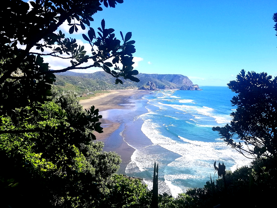
The Laird Thomson Trail
Upon reaching the highest point of the Laird Thomson Trail, the view is truly breathtaking. Everything else seems insignificant in comparison to the sheer magnificence before us. The expansive ocean, the sandy beaches, the warm sun, and the gentle breeze create a rewarding experience for travelers who arrive at this stunning vantage point. Looking out towards the ocean, Piha Beach stretches out to the left, while the famous White's Beach lies to the right. This smaller beach can be viewed from Te Waha Point, which was once the site of a Māori pā fortress. Today, this small promontory, surrounded by steep cliffs, is home to grey-faced petrels that nest in the ground around the roots of pohutukawa trees.
How to Get to the Beach
White's Beach can be accessed via two main routes: first is Laird Thomson Track. This trail begins at Kohunui Bay at the end of North Piha and leads you to the beach. The second route is Marawhara Walk. Starting from North Piha Road, directly across from the North Piha Campers' Club, this path connects to the White's Beach Track, which ascends steeply to Anawhata Road. Please note that swimming at White's Beach is not advisable as there are no lifeguards on duty. If you choose to venture into the water, it should only be done when the weather is calm and conditions are safe, as swimming here can be risky.

Brief History
The beach is named after Francis White, a blacksmith whose son, also named Francis, negotiated the purchase of much of the West Coast land from the Te Kawerau ā Maki tribe. In 1861, Francis White received a crown grant for 600 acres north of Piha. Although he likely intended to harvest the kauri trees in the area, the trees remained largely untouched due to the difficulties associated with logging the massive timber.

In the Footsteps of Edmund Hillary
In 1925, Jim Rose purchased the land at White's Beach from H.A. Mobbs. Jim's daughter, Louise, later married Sir Edmund Hillary, the first person to summit Mount Everest. Sir Edmund Hillary conducted much of his physical training on coastal trails, and today, Hillary's Trail honors this pioneering mountaineer. Walking the same paths that Sir Edmund Hillary once traversed is a point of pride for many visitors. Additionally, in 1960, Jim Rose donated Te Waha Point to Piha Regional Park.

In Conclusion
Photos, personal experiences, and testimonials from tourists and enthusiasts all point to a simple truth: if you have the opportunity to visit New Zealand through Auckland, you must add Piha to your list of must-see destinations. The natural beauty of Piha, especially on a clear summer day, will captivate your heart and deepen your appreciation for this remarkable country. If you don't already love New Zealand, a visit to Piha is sure to make you fall for it.


Comments